In 1935 a journalist by the name of H. J. Massingham wandered on foot over the chalk hills of southern England. He described his journey in 'The English Downland'.
For several years after reading the book I thought of doing the same thing. However, there were difficulties. Massingham was a professional writer, financing his travels through his work, while the rest of us have to pay our own way. I had a route in mind, but couldn't afford to do it in one go. So I decided to break it up, starting each new stage where I finished the previous one.
Leaving Bath I walked through the Vale of Pewsey, across Hampshire and along the South Downs Way to Eastbourne. From Dover I followed the North Downs Way to Farnham, and on to Winchester, Salisbury and Dorchester. A brief diversion across the Isle of Wight and Purbeck brought me back to Dorchester. I continued west, to Winyards Gap, where I turned east and north east to Salisbury. Then west to Mere and Warminster. There I joined the Wessex Ridgeway on its journey to Avebury. The last leg was along the Ridgeway to Ivinghoe Beacon.
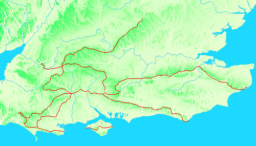
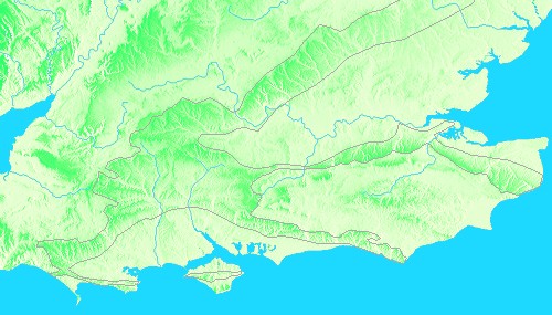
The first image is a relief map of southern and eastern England, with the main areas of chalk outlined in grey. The second shows the route so far.
The largest area of chalk downland lies in Wiltshire, spilling across the border into Hampshire. From the main body a broad ridge runs south-west down into Dorset. Two longer arms, the North Downs and the South Downs, embrace the Weald.
There's another upland just to the north: the Marlborough Downs, bounded by the Vale of Pewsey and the Vale of the White Horse. Across the Thames this becomes the Chilterns, running north-east to Norfolk.
The maps here don't cover remoter outcrops, such as the Yorkshire Wolds. I'll add these if I ever get there!