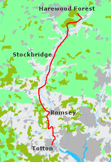
I set out from Totton, some years ago, on a soft spring morning. Although only March it was warm for the time of year. A fine rain dripped down from a grey sky, but it was harmless stuff, little more than mist. The sort of weather in which clothes dry as you walk, and waterproofs do more harm than good. It might have been damp, but it did not look ominous. The forecast described the outlook as "changeable".
Totton on a dull day is not much of a place. The town centre is dreary, like so many others. Everything seemed dreadfully familiar - same shops, same offices. Even the public toilets, which like the rest of the place might be described as 1970's Bog Standard. An unhappy jumble. I sat on a bench by the side of the road, looking round and breathing in the cool air. My head ached after seventeen miles in a crowded bus.
The Test Way begins - or rather began - just north of the town centre. These days the official starting point is Ealing Tide Mill, half a mile to the south; but when I walked it, it was at the pub known as the "Salmon Leap" (the original signpost, informing whomsoever it may concern that Inkpen Beacon is 44 miles away, can still be seen nearby). Totton is easy enough to navigate, as the city streets are clearly marked on the OS map. From the pub the Way follows a metalled track, but soon it wanders off through the marshes, crossing the sluggish stream. Reedbeds grow along the water's edge; duck and waders gather on the rich mud flats; while overhead the squabbling seagulls wheel.
The Lower Test is an uncertain landscape. Here the cool green of the countryside merges with the bright harsh world of the sea. It's pleasant enough, especially on a fine day, but that morning I found it all rather depressing. Perhaps it was the weather: the rain had started to come down in earnest. Or the dirt and decay which cling to the margin of cities. To the east lay the uneasy sprawl of Southampton, unseen but slightly disquieting. It exuded a faint menace, corrupting the quiet countryside.
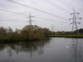
The footpath ran beneath some power lines, past an enclosure strewn with broken vehicles. For a while it skirted the meadows, muddy and wet, where cattle wallowed; then bending abruptly it hurried through a broad passage under the motorway.
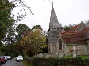
Emerging from the gloom, I turned into a narrow lane leading to a cluster of cottages. Outside a country church there was a bustle of activity; it was the weekend before Easter, and some of the parishioners were decorating the building. I stood in the porch for a moment, embarrassed by my rucksack and the state of my boots. Seeing my hesitation a pleasant lady invited me in and showed me round. There were flowers everywhere. The air was heavy with the smell of polished wood and the clean fresh scent of spring. At first I felt uncomfortable, walking round in jeans and dirty footwear, and as we proceeded through the church I became aware that I was leaving a trail of mud. But the feeling soon passed: there was such a sense of quiet kindness among the people working together, that a bit of mud didn't seem to matter. I stayed in the church for the better part of an hour, and when I came out the rain had eased. I set off once more, cheered by their friendship and goodwill.
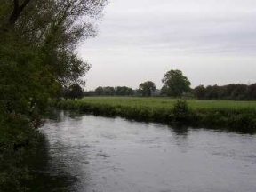
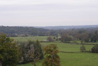
For several miles the Test Way wanders about, unsure of where it is going. It moves hesitantly northward, then slides off at a tangent and edges south. Eventually it settles down on the west side of the river, acquiring more conviction. It is a pleasant path to walk, flat and undemanding. I followed its rambling course at an easy pace, along hedgerows, through fields blurred by the gentle drizzle. This is rich and fertile soil. Low hills dark with ancient woods rise up on either side, watching over meadows fed by the tangled stream. Bovine aristocrats, ruminating, browse the sweet grasses, gazing with mild condescension upon passers-by. The path itself paces steadily along the line of the river, at a little distance from the water's edge, until it passes Broadlands and enters Romsey.
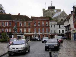
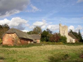
As I approached the town I could see the squat shape of the Abbey over the flat fields. A curious building, dumpy and out of proportion; it looks as if it has settled down comfortably and does not mean to move. Not elegant, perhaps, but it feels friendly and approachable. Romsey itself is an attractive place, and would be more so if it were not for the noise and confusion. The town centre that morning was drowning in the roar of traffic. People gossiped on the pavements, making steady progress with a rucksack difficult. I was careful to buy some food while I was there, since with the exception of Stockbridge there are no shops anywhere to the north. Then I crossed the stream and strode out once more. Near the edge of a wood I paused and looked back across the water meadows, to the river and the stumpy little tower of the Abbey. In spite of its odd appearance, in those surroundings it somehow seemed to fit.
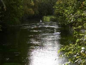
For the next few miles the Test Way wriggles its way through a tangle of woods, fields and hamlets, crossing the Southampton-Salisbury line before reaching Mottisfont. This kind of walking can be hard work: you're obliged to stop every few minutes to check the map, which makes progress difficult. Paths are often overgrown, there are stiles to negotiate, and nothing goes where it should. I skirted the walled gardens of Mottisfont Abbey, now owned by the National Trust, and descended a gentle grass slope to the river. The Test flows in several channels here, as it does for much of its length. By the bridge at Lower Brook I rested for a while, watching the bright water twisting in profusion as it tumbled down from the weir.
Across the stream the going improves. The footpath follows the line of a disused railway, running straight and sure for eight miles to Leckford. You can move quickly, rolling along with only a cursory glance at the map. As I walked, the countryside opened up around me. Here the short broken slopes of the lower Test merge and are transformed into smooth, sensuous curves. The woods drop away, leaving flowing fields and high downs touching the hastening sky. Near King's Somborne the Clarendon Way strides imperiously down from the hills and across the vale on its march from Winchester to Salisbury.
That afternoon there came a change in the weather. The wind shifted and the clouds were swept up by a fresh breeze. I stopped briefly to see Stockbridge, then pushed onwards. The declining sun shone over the fields, warming the brown earth and lighting up the new leaves and the drifting clouds of blossom in the hedge rows. The path left the railway line and clambered briefly over the burrowed slopes of West Down, before dropping back to the river. I came to the water's edge and looked out over the valley. The clear stream lay tranquil in the soft evening light, and the downs rose up in the sky. At the end of a long and tiring day, the sight of it stopped me in my tracks.
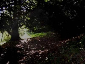
It was starting to grow dark under the trees as I cut through Harewood Forest. I am not particularly worried about being out alone at night - I have done it too often - but it does make map-reading a bit tricky, especially if you are not carrying a torch. The path was descending towards farmland, and I still had to find somewhere to spend the night. In the end I decided to carry on to the woods above Middleton Farm and look for a spot up there. I was just about ready for bed by now, and not paying much attention to the scenery. Approaching Longparish church over the fields I chanced upon three roe deer, which had come down in the half-light to drink. Nervous, velvet nostrils twitching, they bowed their heads to the quiet stream. I froze in the shadows, watching, until something spooked them and they bounded away into the night.
It was growing cold, and white stars were shining as I felt my way through the trees. After a couple of miles I stumbled onto a small plateau next to the path, which seemed promising. A clump of beeches overlooking a shallow valley offered some sort of shelter. With frozen hands I strung the bivouac from a low branch. Then I unrolled my sleeping bag and burrowed down into the deep carpet of leaves, seeking for warmth. It was not easy to come by. The night was bitter. Groping fingers crept under the trees and seized me in an icy grip. I lay curled up, mute, unable to move. To have slept at all, I must have sunk into some cataleptic state bordering on hypothermia. But sleep I did, for when I awoke the red sun was rising over the frosty fields, and it was morning.