Awake in the half-light of dawn, after a hot and restless night, it seemed a good idea to get going before anyone came along. I packed quickly and clambered back onto the right side of the gate. Breakfast was a mug of muesli mixed with energy drink, a strange combination to say the least. Then off along the ridge once more, as day broke and the soft grey landscape acquired form and colour. At six o'clock I had the world to myself.
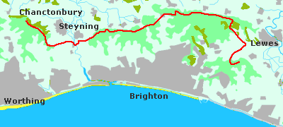
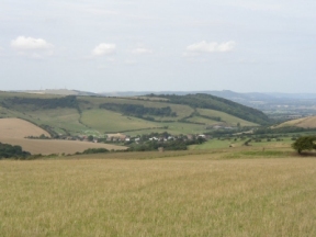
It was a dull morning but not actually raining. From Swanborough Hill the track bends south, skirting a wide bay in the chalk as it drops down to the A27. After the road it traverses Long Down before climbing once more. The slope seemed to go on forever, on rutted paths through wide scraggy fields. For a long time I could see the ridge up ahead, but it never seemed to come any closer. Finally I reached Black Cap. From here the South Downs Way follows the escarpment, an upland way running for nearly fifty miles to Butser Hill.
Consulting the map I reckoned that I had at least an hour to spare. I was aiming for the pub at Pyecombe, and there was no need to be there until midday. Tired from the early start I slept for an hour on the turf.
That morning there were few pedestrians about. Most people seemed to be running purposefully, or cycling - as if they were trying to pack as much exercise as possible into a few brief hours. It seems a feature of life today, that though we are more prosperous than ever before there is no time to relax. Even pleasure must be be fitted round the busy schedule that pays for it.
After several miles of rolling downland the track begins the long descent to Pyecombe. Near the bottom it crosses the line of the London to Brighton railway, which here passes through the Clayton tunnel. While the trains run silently below ground, the trucks that share this gap in the hills most certainly do not. As I came to the pub the thunder of traffic shook the air.
The Plough is described in the guidebook as a walker-friendly establishment; though with its cool, modern interior and uniformed staff this was not immediately apparent. I need not have worried, though; it proved to be a welcoming place, and lunch was substantial. I ate outside in the sheltered patio garden; and afterwards I sat for an hour in drowsy sunshine. I could have slept away the languorous afternoon, but I had to push on if I was going to get anywhere that day. Reluctantly I left.
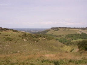
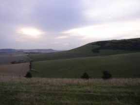
Across the main road, dodging the juggernauts sweeping south to the coast, I took to the hills once more. The path climbed quickly, brushing the shoulder of West Hill before beginning the long ascent of Summer Down. To my right I caught glimpses of the chalk coombe known as the Devil's Dyke. This area is managed downland, one of several which aim to reverse some of the damage caused by the Common Agricultural Policy. Sheep browse among thorn bushes, cropping the turf. They help to maintain the fragile balance, which the plants and insects of the chalk country desperately need if they are to survive.
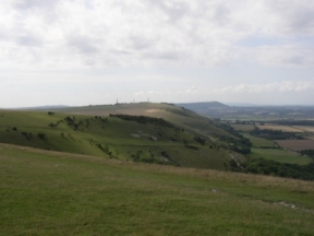
It's worth making a short detour round the head of the valley to the Dyke Hotel. The views out over the Weald are impressive, though they would have been more enjoyable that day had I not been forced to keep a constant eye on the kamikaze kite fliers. Fortunately they never move far from their cars, and I left them behind as I headed out to Fulking Hill. Then on and over Edburton Hill and Truleigh Hill, expansive ridge walking all the way. Past Tottington Barn Youth Hostel, and I began the long slow descent to the Adur in the afternoon sunshine.
Crossing the river I diverted to Steyning to find something to eat. As it was a Sunday the possibilities were limited, but there were a couple of shops open. I had walked off the edge of the map, and I was unsure how to get back to the South Downs Way without retracing my steps; so I asked a suspicious local out walking with his wife. Where was I going, he wanted to know. Up to the ridge, then heading west. And where was I sleeping? I wasn't going to admit to anyone that I planned to pass the night under the stars; so looking as innocent as I could I replied that I hadn't quite made up my mind. He stood and stared as I walked off.
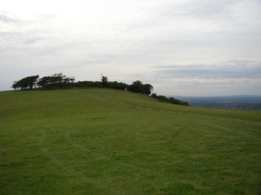
I regained the path, climbing through hushed woods. It was that wonderful time of the evening when a sudden peace falls over the world. The breeze died and the birds faltered and grew still. I wandered on in the cool twilight, wrapped in a profound silence. Away to my right an owl hooted. After a couple of miles I reached Chanctonbury Ring, where I hoped to camp. It seemed a decent enough place, and the gathering night offered sufficient concealment. After scouting round I found a spot on the west side of the Ring and settled down.
It was after midnight when the weather broke. Restless, I awoke to a foreboding quietness, then without warning the trees groaned as they were tossed by a blustering wind. Swollen clouds spread over the sky, eating up the stars. I listened as the first drops pattered onto the taut fabric of the bivouac. I could feel them on my face, so I burrowed further inside. Not that it did much good; driving rain swirled over the hilltop, falling from every quarter. Pools of water formed on the groundsheet, soaking the sleeping bag. I had spread my walking clothes on the rucksack to air, and reaching out in the darkness I found that they were already wet. I tried to rearrange my gear, but in that confined space there didn't seem to be anywhere dry to put it. At last I gave up and lay there, listening to the storm raging outside, waiting for the dawn.