
I've done the South Downs Way twice now. An account of my second trip, from Winchester to Eastbourne, can be found here.
The South Downs Way is 100 miles long, and quite hilly in parts. Five days would be good going, though six or seven may be more realistic. The scenery becomes more spectacular as you travel east, though as in the case of the Ridgeway it is still rewarding to walk it the other way. If you do, you wander through the quiet intimacy of the Hampshire countryside to end at Winchester. Travel west and you cross the airy cliffs of the Seven Sisters and drop down to the seaside town of Eastbourne. It's your choice.
Places to eat and sleep are reasonably frequent, though sometimes they are a few miles off the Way, especially towards the western end. The track is generally well waymarked, and it keeps to the ridge for much of its length so you are unlikely to go far astray. Even in August I found it surprisingly uncrowded, though it would be sensible to book accommodation in advance, especially during the summer months.
I didn't carry Ordnance Survey maps on this walk. I used the National Trail Guide by Paul Millimore and never got lost. The only problem I found with it is that the maps it contains are rather narrow. They show the trail, but if you deviate in search of food or accomodation you might yourself walking off the edge. Free extracts, which can be used to fill in the gaps, are available from the OS website.
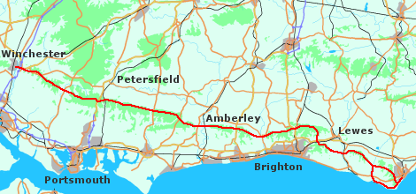
There's an aerial overview of the walk here.
Other sites
I could only find a few descriptions of the SDW, though more articles seem to be appearing every year.
- Bod's Blog contains a recent account of a walk along the South Downs Way. Good stuff!
- David Cotton describes the walk, from west to east.
- Clinton Andrews walked the trail in sections, while based on the South Coast. With photos.
- Peter Chatfield's article about his trip. With photos.
- Anthony Beggs is actually a cyclist, but it's a nice site, and there's some interesting general information plus photos.
- An lastly an amusing account: a beery glimpse of the South Downs Way!
General information:
- Ramblers Association: route info and accommodation details.
- National Trails
- Rural Ways
Accommodation:
- The White House, Pyecombe: they were full when I got there, but I've heard good reports of this B and B.
- Hobbs Cottage, Pyecombe: this one did have a room. Very friendly, a comfortable bed and an excellent breakfast. I would certainly stay there again.