From Winyard's Gap the downs runs for twenty miles to Shillingstone, before bending abruptly north. This L-shaped upland encloses the eastern end of the Blackmore Vale.
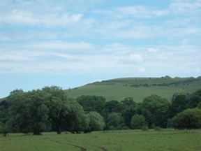
The Vale is drained by the muddy Stour, which breaks through the angle of the chalk. At Shillingstone it winds round the foot of Hambledon, a high hill guarding the river valley and the passage to the sea. Both Hambledon and its twin, Hod Hill, were fortified camps during the Iron Age.
On my previous vist to Shillingstone the Old Ox was closed. Happily it has now reopened. The hours, though, are rather irregular, so would be worth checking in advance if you were planning to eat or drink there.
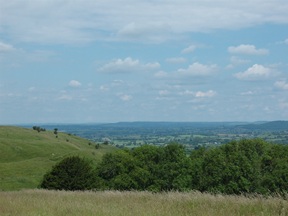
From the village a footpath crossed the level fields to the river. On the other side it passed through an estate, then headed for the sky. The climb was a long one, but uplifting as the valley was shrugged off and the country opened up - sensuous curves of downland, ridge after ridge, and beyond all the blue dome of the sky.
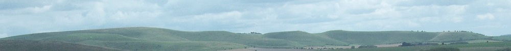
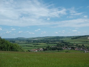
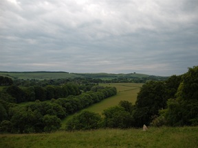
The view from the trig point was sensational. Over the river the ridge ran westward to Winyard's Gap, a two-day journey on foot. South and south-east lay the Dorset uplands and the Purbeck Hills. The long wooded slopes of Cranbourne Chase rose up ahead; while to the north I could make out Shaftesbury, and further still the high downs beyond Mere. There are few 360 degree vistas in the chalk country; and on a clear day this must be one of the finest.
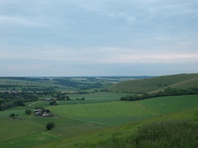
On the far side of the hill a long spur leads down to Shroton, a pleasant village in the Iwerne valley. I had time to stroll round it, as the Cricketers (last pub for miles!) was not yet open. The afternoon was warm, with the sultry menace of summer which spoke of stormy weather to come. As I left the village a thin veil of cloud covered the sun.
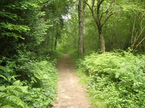
Leaving the village I climbed through fields where the air lay heavy on the hot earth. As I entered Cranbourne Chase, though, the way grew more wooded. The path led on, listlessly, through dense brakes of hazel. There was little to see, but on that oppressive afternoon I wasn't chasing views. Just to be out of the harsh light of the sun was enough.
Somewhere up in the woods I met up with a Wessex Ridgeway walker, coming from Marlborough. He told me that parts of the trail, in Wiltshire particularly, are now badly overgrown. I do remember from a previous walk that the Ridgeway between Warminster and Win Green, particularly the section south of Hindon, is not the best walking, though the downland sections at either end more than make up for it. Perhaps the best advice is: if you are doing the Wessex Ridgeway in summer, make sure you have something other than shorts to hand!
After the shelter of the woods there is a long hot slog over stony fields to Ashmore. This is an attractive place, with a pond set amid a cluster of brick and flint cottages. I dozed for an hour by the cool water, then set off once more across the hot upland to Tollard Royal.
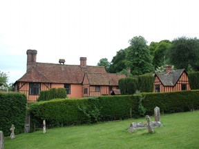
Tollard Royal - the haunt of kings. There was a hunting lodge here once, on the site of King John's House which lies just behind the church. The house itself was owned by General Pitt-Rivers, one of those Victorians who managed to cram about three lifetimes into one. Soldier, landowner, prehistorian, collector, the artefacts he amassed are now on display in the Pitt Rivers Museum in Oxford. His greater legacy, however, may be as an archaeologist. The army had taught him the importance of observation and meticulous recording, techniques he applied to excavation - and this at a time when digs generally consisted of gangs of men under the direction of the local vicar, shovelling away barrows in the hope of finding treasure under them. His work helped set the standards for modern archaeology.
It was late in the afternoon when I left Tollard Royal. There are several ways to reach the ridge which lies to the north of the village, depending on where you are heading next, but as I was making for the Talbot at Berwick St. John, I took the long sloping track which leads past the pond. It's a two-mile climb to the top, where the Oxdrove runs west to Win Green and east towards Salisbury, but an easy descent through the lanes to Berwick.
I ate outside, under a sky growing blacker by the hour. A few drops fell as I left the inn. The light was growing dim as I hurried along the lane to Woodlands and began the long climb out onto Whitesheet Hill. I had two hours at most to find somewhere to pass the night.
I scurried along the ridge, eastward, looking for a bit of woodland where I might string a bivouack without attracting too much attention. Everywhere I came to was either bramble-infested or fenced off. As the rain came down and it grew too dark to go any further I came upon a double row of trees, flanked on either side by a rough track. It was not ideal, but by attaching one end of the bivvy to the trunk of a tree and the other to a precarious tripod made of fallen branches I managed to make myself a shelter for the night.
There is a certain satisfaction, lying there in sleeping bag, listening to the rain drumming on the thin layer of nylon which separates you from the elements. That night it poured, but my little bivvy coped admirably with the deluge. And I slept like a dead thing.