I passed a warm and fairly comfortable night under the trees. I was awake by five, though there was no need to hurry as the dawn would not break for at least another hour. Although it had been raining at some point the flysheet / groundsheet combination proved very effective. Over the course of the next couple of days the sleeping bag did become slightly damp, due to the cold and humidity, but it was never unusable. Had I been out for longer than three days I might have looked for a launderette with a drier, but for the time I was walking it wasn't a problem.
I was ready to leave when I discovered that I had mislaid my wallet. Frantic search. I found it, after I had turned everything out, right at the bottom of the rucksack! I finally got started at seven.
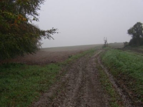
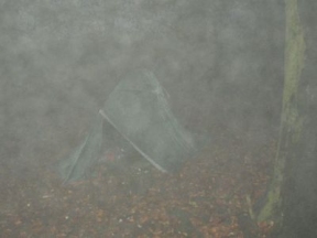
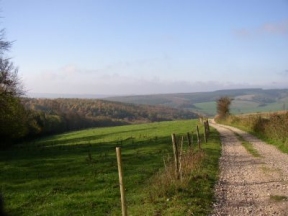
It was a dull morning, though not actually raining. The muddy track led away through fields, hugging the curves of the hill. I could see little, just vague shapes in the mist, but I plodded on in good heart. For the first few miles the way was easy to follow, over Bignor Hill and down to Littleton Farm. On Littleton Down, however, it had been ploughed out and had not been reinstated. According to the map there was a gate somewhere up ahead, leading into a wood. I couldn't see it in the gloom, so I set off in what I hoped was a straight line, steering by the rise and fall of the ground. After a while I came to the fence, more or less in the right place, and passed under the trees.
At Tegleaze signpost I felt it was high time for breakfast. I find that I can walk for a couple of hours with just a coffee, but then I need to stop and eat. While I sat there waiting for the stove to heat up I noticed that the mist had begun to burn off. I still couldn't see much, but there was a hint of better things to come. For the next few miles the Way passed through woodland, damp and smelling of mushrooms. Shafts of sunlight filtered down, illuminating the mysterious depths of the forest. Now and then through the branches overhead I caught glimpses of blue sky; and as I emerged onto Heyshott Down the wide world lay spread out before me. A fresh breeze blew from the east, keen and cold, and the bright sun shone in a pale sky, washing the hills with colour. It was a heartening sight, and I quickened my pace as I descended to Hill Barn.
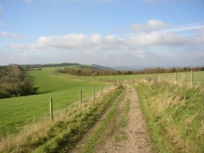
Happily, the tap by the track was working. There are few sources of water on the western half of the South Downs Way, and fewer pubs, so it is as well to make use of whatever is available. Bottles replenished I clambered up to Cocking Down and over Didling Hill, an exhilarating walk on the high chalk. After three miles the path bent south through a plantation before emerging onto Beacon Hill. The official route bypasses the hill, but there is a footpath to the top. The climb is well worth it for the views in every direction.
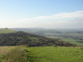
After Beacon Hill the landscape alters. The South Downs really come to an end here. The abrupt edge that has defined the Way for seventy miles merges imperceptibly into a landscape of gentle slopes. The downland chalk gives way to heavier soils, and the wide sheep country is left behind. For much of the last thirty miles the path crosses rich arable and pastureland. I could sense the change as I passed the folly on Tower Hill and followed Forty Acre Lane. A mile further on I crossed into Hampshire.
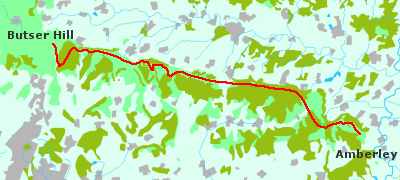
The short winter's day was drawing in and it was growing cold. I needed to find somewhere to camp for the night. Butser Hill looked a good bet, but it still lay some way ahead. I had already walked the best part of twenty miles and was starting to feel tired; but there was some consolation in the thought that every mile covered would be one less to do the next day. I pressed on along tracks and lanes until I reached the Queen Elizabeth country park, dark and forbidding on that winter afternoon. The path dropped down through damp woods that seemed to run on forever. At one point I tried to be clever and take a short cut. It would have been better to stay on the official track, but I found the visitor centre in the end. There is a water point there, although it is not shown on the map.
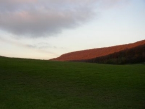
The light was failing as I left the car park and climbed Butser Hill. Across the valley the last rays of the sinking sun lit up the trees. There were still a few people about, so I did not hurry. After scouting round I came upon a suitable spot, screened by a line of trees, where I sat myself down, waiting for everyone to leave. A pleasant woman stopped for a chat. "You look as though you're settling in for the night!" she said. Oh well, why deny it! She was friendly enough and interested in what I was doing. As soon as it was dark I pitched the tent and cooked some food. Then I sat outside for a while, gazing at the lights of Portsmouth far below, listening to the sounds of the night.