I reached Bristol in the grey light of morning. For an hour I sat, waiting for the Exeter train, listening as the hushed station came slowly to life. Then on and out over the waste of the Somerset Levels, beneath a blanket of cloud blown in from the Severn Estuary.
As we came down into Devon the weather improved. The rain eased, and the flat landscape of Somerset gave way to steep-sided hills and the red earth of the West Country. At Exeter I changed to the Tarka Line; travelling north-west, through farmland heavy and prosperous, to Barnstaple.
From the town a little bus runs onward, rambling over the rounded hills to Lynton. As we travelled I began to catch glimpses of the great mass of the moor, rising over the fields. The driver was a friendly chap; acquainted with most of the inhabitants of Devon, judging by the fanfare on the horn as we passed through hamlets and villages. He set me down by the Tourist Information office.
For fifty pence they supplied me with a photo-copied list of accommodation along the route, and for rather more than that the 1:25 000 Ordnance Survey map of Exmoor. It is possible to walk much of the Two Moors Way using the extracts in the Ordnance Survey Recreational Path Guide, but on Dartmoor and Exmoor you should really carry proper maps. Both places demand a certain amount of respect. Pleasant enough on a fine day, they can be very unpleasant indeed in mist and rain. It is important to be aware at all times how to get off them quickly. Even in fine weather, anyone venturing up there should have good footwear, and carry warm clothes, waterproofs, compass and whistle. A fall or injury, especially when alone, could spell trouble.
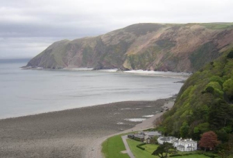
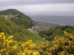
The wind was blowing from the north as I came down to the river. Shafts of sunlight fell onto the rolling sea, touching the gaunt headlands with unexpected colours. The path climbed quickly away from the rocky stream, tacking upwards through oak woods heavy with the scent of wild garlic. I walked slowly, taking time to become accustomed to the weight of the rucksack. Even so, I had stripped off several layers of clothing by the time I reached the top. There I could move more freely, striding out along the escarpment, getting into the rhythm of the walk. To my left long wooded slopes crashed down to the valley floor. Primroses sheltered among outcrops of grey stone. The path was littered with twigs torn from the stunted trees: a sign of the fierce winds that come rampaging in from the sea.
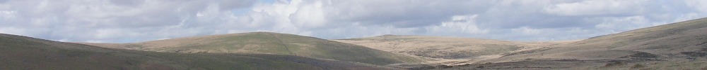
The abundance of wild flowers struck me as I walked. Bluebells, primroses, red campion, violets, wood anemones, sorrel grow in profusion in those warm wet valleys. Above the tree line the air was thick with the scent of gorse. As I climbed the countryside became wilder and more open. Slowly the clinging woods fell away and I came out onto the moor.
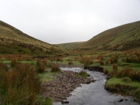
On Cheriton Ridge I walked into the clouds, and it began to drizzle. The temperature dropped rapidly and I had to stop and put on a jacket. I pushed on, using the compass to guide myself over the wet grass. Dropping down to Hoare Oak Water I stumbled unexpectedly upon a small herd of Exmoor ponies. They scattered in terror as I loomed out of the mist. I stopped by a pool, watching as a pair of dippers chased each other from stone to stone. Higher up, a buzzard rose out of a tree and swept contemptuously away over the moor. The path followed the stream, winding along the floor of a narrow valley before climbing steeply to Exe Head. From this high place the River Exe begins its long journey south to the sea.
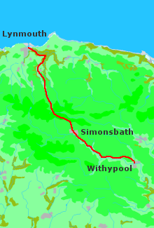
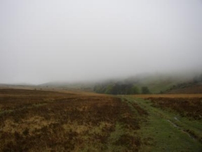
As I emerged from the shelter of the defile, the full force of the wind hit me. The clouds darkened, and the rain came down in earnest, whipping over the exposed hilltop. My waterproof trousers were at the bottom of the rucksack, and I did not fancy unpacking everything to get them out; so with misplaced optimism I left them, sure that the shower would not last long. When it became apparent that it had set in for the day, I was so wet that there was not much point in putting them on. I peered at the map, trying to decide which was the best way to go. Dure Down did not look appealing; but if I could get into the valley of the Barle I would be able to follow the river to Withypool. The alternative route seemed to involve a long trek out over bleak moorland. Cold and wet, I squelched off through the mist towards Simonsbath, in what I hoped was the right direction. There was no track to be seen; but I knew that a road cut across the line I was walking, and I was bound to hit it somewhere. I pushed on along a rough bearing, stumbling over the sodden peat, until I came to a fence. After that, at least I had something to follow, though the attentions of a herd of curious cattle did not add to the dubious pleasures of the moment. Eventually I found a gate out onto the road.
I could have walked into Simonsbath along that road, but I chose to follow the footpath down through Ashcombe Bottom. And apart from the mud, and the cold, and the mist, and the fact that I managed to get lost, it was not a bad stroll. Simonsbath, when I eventually reached it, was deserted. A quiet, creepy place on that dark afternoon, silent as the woods that concealed it, wrapped in a ghostly veil of falling water. It might have been a plague village, or some blasted settlement deep in the forests of Transylvania. The Exmoor Forest Hotel was shuttered and still; it looked as though it had been abandoned altogether. I gave up hope of temporary shelter and plodded on through the rain.
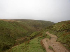
It is six or seven miles from Simonsbath to Withypool, and it just kept on pouring. For the most part the track stays close to the River Barle, winding through a long moorland valley. I hurried along, pursued by a wind that tore down from the heights. Tattered curtains of rain flapped wildly in the sudden squalls; at times the drops were hitting me sideways. The valley seemed to run on for ever, deep into the cold heart of the hills. At one point the track left the stream, and I peered anxiously at the map, water streaming into my eyes, trying to work out where I was. It did not seem a good time to get lost. Then, after several miles, the path plunged into a wood of tall pines, a brief respite from the relentless wind. I stopped for a while in the cathedral darkness, listening to the storm battering the branches high overhead. There was a patch of wet grass where I might have camped, but I was cold and hungry and in no mood for the great outdoors. The thought of a night in a damp sleeping bag and nothing to eat did not appeal. So I left the shelter of the trees and swung out once more over the moor. Soon the path left the stream and climbed up onto a shoulder of land. I trudged along, taking a perverse pleasure in splashing through the puddles. I was so wet that I could have waded through the river itself and it would have made no difference. Finally the open moor gave way to fields, and the track ran into a lane and dropped down to Withypool.
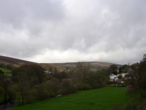
I approached the Royal Oak with some misgiving. It calls itself a Residential Hotel, and has a rather nice restaurant and a couple of stars into the bargain. The kind of place where respectable middle-aged people go for a quiet weekend in the country. I walked into the bar, straight off Exmoor and looking a mess. To their eternal credit, the people there didn't even blink.
Thankfully there was a room free. And a very pleasant one it was too. I unpacked as well as I could with frozen hands, trying not to drop any mud on the carpet. After a bath and a few beers I felt better. I ate in the bar, slowly, enjoying the food and the warmth of the fire. In the lane outside I could hear the rain splashing down. Then at last, overcome by exhaustion and unable to keep awake any longer, I took myself off to bed. I don't remember anything more.