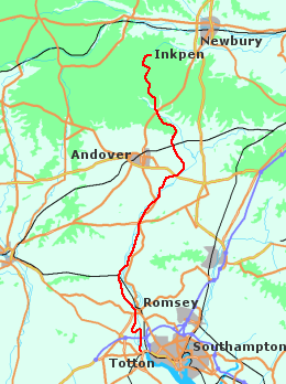
The Test Way walk is about forty-four miles long, running from Totton, on the edge of the Solent, to Inkpen Beacon, above the Vale of Pewsey. Although shorter, it is a little more challenging than the Kennet and Avon; say two longish days, or three easy ones. It is is mostly on footpaths, and there are a few climbs en route. Some people prefer to follow rivers from source to sea, but in this case I would recommend doing it the other way round. The scenery improves as you travel further north.
There are railway stations at Totton / Southampton, and at Hungerford / Kintbury. The only places of any size on the way are Romsey and Stockbridge - Andover is a few miles off the path. Both of these lie on the southern section of the walk. Further north, the Test Way passes through several villages; principally Chilbolton, but also Wherwell, Longparish and Hurstbourne Tarrant. The first three have pubs, so there should be food and shelter available somewhere (there's also one marked on the map at Hurstbourne Tarrant, though when I passed through in the summer of 2005 it appeared to be closed). Other possibilities, just off the Way, include Dunbridge and Horsebridge to the south, and St. Mary Bourne and Stoke further north. All have pubs, though you would need to check to see if they provide accomodation.
From Mottisfont to Leckford the Test Way follows the old Sprat and Winkle line. Further north it passes close to Ibthorpe House, once owned by close friends of Jane Austen, who often stayed there (later it became the home of the painter Dora Carrington).
The relevant map numbers for the walk are Landranger 196, 185 and 174, listed from south to north. There are a number of articles about short sections of the route on the Internet, though I couldn't find a free guide to the whole thing. Still, who needs guide-books! It's a pleasant walk, and well worth the effort.
Other sites
No descriptions as such. Try:
- Hantsweb: Hamphire County Council's page has a useful overview.
- Ramblers Association: accommodation service and route information.
- Test Valley: another official-type site with some accommodation info.