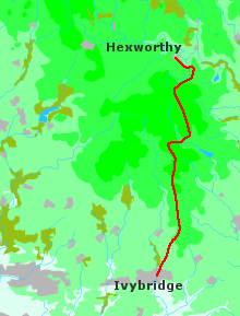
I felt great as I set out from Hexworthy. The morning was cold, though high white clouds gave promise of fine weather to come. As I followed the lane I breathed again the damp exciting air of the high moors, a smell that brought back childhood memories of walks in the north of England. The blisters on my feet had hardened, and after four days I was starting to feel extremely fit. And it was my birthday.
There are no proper tracks on this part of the moor, and I had spent some time the previous evening pondering the map, trying to decide which route might be walkable. I eventually elected to climb the spur south of Combestone Tor before bearing right over Holne Ridge to Ryder's Hill. From there I could keep to the high ground, walking from cairn to cairn as far as Pupers Hill before rejoining the Two Moors Way for the last miles to Ivybridge.
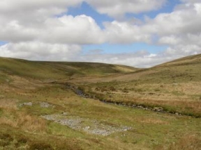
From the road a rough track led away through the heather, but it soon petered out. As I climbed I had a comforting view to my right of the curiously named O Brook. I worked my way round the head of a rocky scar high above the stream, then struck off southwest on a rough compass bearing. As the ground levelled out it became wetter underfoot. I had no visible landmarks up ahead to guide me, and there was no easy way through the soggy black peat. I followed the compass, trying as far as possible to keep to the dry patches, glad that the weather was fine. It would have been miserable up there in mist or rain. Finally I stumbled upon a trodden path where it cut through a natural bank of earth at Wellaby Gulf. It wound over the peat in a reassuring line south to Ryder's Hill. I could see the summit cairn in the distance.
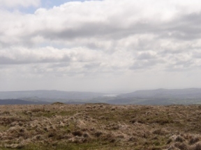
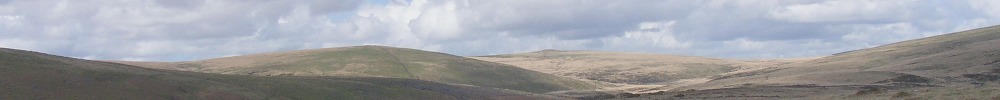
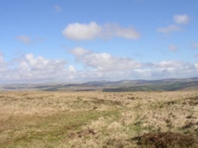
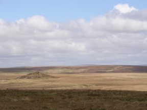
A wide swathe of heather had been fired up there on the ridge. As I walked my boots kicked up clouds of acrid dust. On the hill shaggy cattle browsed the scanty vegetation, gazing incuriously as I passed. I stopped by the cairn to take in the view. Far ahead I could make out the white gash of the china clay works on Lee Moor; to the east lay the estuary of the Teign, a burnished blade stabbing the shore; southward the shining light in the bright sky spoke of the sea. North and west the moor lay desolate, empty, a waste of undulating nothingness.
From Ryder's Hill to Snowdon the ridge was like a wet sponge, and progress was slow and difficult. I floundered over a carpet of coarse grass, splashing through hidden pools. From the cairn, however, a straight path led over Pupers Hill down to the junction of two tracks. The Two Moors Way passes somewhere near here, marked on the map by a vague scatter of diamonds running over Hickaton Hill; but I never found it. In the end I followed the broad path to Western Wella Brook, then found a way down to Huntingdon Cross.
Silence. It might be the very heart of the moor. A rocky stream runs down through swelling slopes of grass where black sheep browse. In that place no sound from the outside breaks the stillness. Only the wind and water, and the drifting sky. I sat by the granite cross, feeling utterly alone, wondering which way to go. According to the map the path heads upstream for a little way, then climbs out of the valley and joins the old tramway running down to Ivybridge. Although I couldn't see it, I knew that if I walked southwest I would be bound to hit the line at some point.
There are actually two tracks, arms of a loop running down from the disused china clay works at Red Lake. I strayed a little but eventually found the one I was looking for. Once on it I could put away map and compass. It crosses the moor in a series of gentle curves, hugging the contours, descending almost imperceptibly into the lowlands. I was content to let it lead the way, following steadily as it hurried on ahead. Those last few miles passed quietly, with little to remember or record. At one point a roebuck got onto the path and skittered along in front of me. I stopped to watch a buzzard sailing on the breeze. An occasional butterfly drifted across the track. For the first time that day I began to see other people.
As I ambled along I thought over the trip. Another journey all but done, another milestone. Looking back, I realized that I had set off with a sort of mental picture of what was to come. Dartmoor was the main concern, especially if it rained; I did not forsee that dreadful day on Exmoor, or blisters in Morchard Bishop. But if the difficulties were unexpected, so were the pleasures: the quiet valley of the Barle, the wind in the high fields, the wide world seen from the moor; and the simple kindness of people I met, who just happened to be there when I was feeling down, and things were going badly, and who helped to make the walk such a memorable experience.
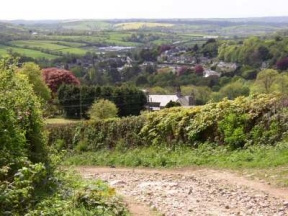
Far below on the valley floor I could trace the course of the river Erme. For a long time it seemed to come no closer, dropping as the path descended; until I swung round the shoulder of Weatherdon Hill, and there at my feet or so it seemed were woods and fields and farms. And there, down through the trees at the end of a long last slope, I saw the houses of Ivybridge.