On this particular trip along the South Downs I stayed on several campsites, and I noticed how much better I slept. Out in the woods I wake up several times a night and I'm generally on the move well before six. On a proper site I get a lie in!
I woke that morning at seven and poked my head out of the tent. It was not actually raining, but it was clearly just about to. A rapid pack seemed in order while there was still time.
I filled my bottles at a water butt, wondering idly whether the contents came from a spring down in the woodland burial area or were the run-off from a yurt. (Probably just tap water.) Then I bade farewell to the sleeping sustainability centre and set off round the rim of chalk to Butser Hill.
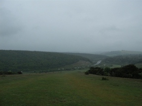
It was a full-wet-weather-gear sort of morning. When I reached Butser the clouds were right down on the hill. A searching wind whipped over the slopes, driving the rain into my face, forcing me to walk with hood pulled down against the stinging drops. There's nothing I hate more than peering out from under a hood; you can't see much further than the ground at your feet. I made for the woods of the Queen Elizabeth country park on the other side of the valley, slithering down a long grassy slope to the visitor centre intent on coffee.
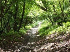
And of course the café was shut, and wouldn't open for at least another hour. Have they no enterprise, these country park administrators? Well I suppose they know their own business, and perhaps it would be uneconomical to have someone there for the benefit of the odd walker coming in from the cold. Nothing to do then but keep going, up the long incline leading up through the trees to the ridge.
I was sitting in a little shelter eating bread and cheese washed down with eco-water when a couple of Roman soldiers appeared. For for a moment I thought it was a hallucination brought on by caffeine deprivation, but they turned out to be real. They were walking the trail for charity, and good luck to them! I wouldn't have cared to be out in that weather wearing only a centurion's uniform.
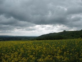
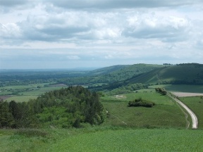
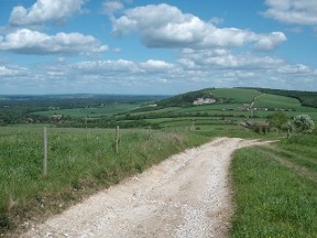
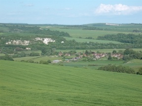
After the country park the way lies along a series of lanes and tracks, on a shelf on the edge of the downs. The area is quite wooded so the views are intermittent. As you progress you start to catch glimpses of the bold face of Beacon Hill jutting out into the lowlands.
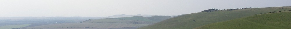
As I walked the sky began to clear. The sun emerged and the grey countryside stirred. From the top of Beacon Hill I could see for miles through the rain-washed air. To my left lay the weald, flat at the foot of the ridge. Up ahead the long chain of downs ran away in the sunshine. A wind, keen and invigorating, buffeted the hilltop. This was the South Downs as it should be!
In the lee of Pen Hill, on a spur with the curious name of Mount Sinai, I found a patch of grass where I could lay out my wet gear in the sunshine. I managed an hour's sleep before it grew too hot. And then onwards, up through the woods to a wonderful section of ridge walking over Didling Hill and Cocking Down.
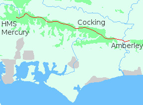
When I reached the A286, at the foot of Cocking Down, it was a quarter to four. I had already covered seventeen miles; and I considered dining in nearby Cocking then returning to the ridge to sleep. The alternative was Amberley, twelve miles further on. In the end I decided to keep going.
From the road the path climbs to the Cross Dyke, where it commences a long woodland section culminating in a sweeping descent to Littleton Farm. From there it rises once more over Bignor Hill and Westburton Down to reach the river Arun and Amberley.
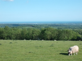
This was the second time I had walked the South Downs Way and I was surprised at how much I could remember. Much of the trail seemed pleasantly familiar; but I had no recollection of this section. I finally realized that the last time I had done it was in thick mist. With no views to anchor memories it had just been a blur. That afternoon the air was clear and I was rewarded by tremendous vistas south to Worthing and the sea.
It occurred to me as I was dawdling along in the sunshine that I couldn't count on getting a meal at Amberley after eight o'clock; and a bag of crisps would have been a serious disappointment after a long march. I started to walk faster, and ended up jogging the last four miles. At the Bridge Inn I got my order in five minutes before they stopped serving. Instead of crisps I gorged on stifado, a Greek stew of beef and onions in a red wine sauce served with rice. They know how to live, these Greeks...
According to the National Trail guide the Bridge Inn offers accommodation. Not true. In fact, nobody there could remember a time when it ever had done. I met some fellow walkers who on hearing of my plight kindly showed me the way to the B and B where they were staying. I could really have done with a bed that night, not to mention a hot bath, but unfortunately the place was full. The girl behind the bar had mentioned a small camping ground on the hill leading out of the village. I eventually found it in the twilight; a flat area of grass on the edge of the quarry, sheltered by a high wall. There were no facilities, not even a tap, and I was the only person there. Still, it was somewhere to stay for the night. Beggars, as they say...