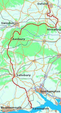
Over the last few years, dozens if not hundreds of new walking trails have been created. Some follow natural topographical features such as rivers, while others link places together using whatever paths happen to lie in between. The New Forest to Oxford walk, my own personal contribution to an ever-growing list, falls broadly into the second category. It starts on the marshy edge of the Solent - for no particular reason, I just happened to be living there at the time - and it ends in the heart of Oxford. Although it is a place-to-place walk, I tried to consider the landscape and to avoid footpaths that wander aimlessly. I prefer those tracks that hurry on to the wide horizon. There are a few meandering bits, but much of the way is straight and open. And there are not many roads. As I walked I had a vivid sense of the slow transformation of the landscape. Destination was somewhere far ahead, time the rhythm of night and day; the ever-changing world was all.
Basics
Distance: at least 120 miles. It took me nearly five days.
Maps:
OS 1:50 000 Landranger Series
164 (Oxford)
173 (Swindon and Devizes)
174 (Newbury and Wantage)
184 (Salisbury and the Plain)
OS 1:25 000 Explorer Series
22 (New Forest)
There are books on the Ridgeway and Thames Valley Path, which contain walking maps of those particular sections.
Getting to the start: Lymington can be reached by train from Bournemouth or London / Southampton (change at Brockenhurst), and by bus from Southampton. If you arrive by train, get off at Lymington Town (the first stop), not Lymington Pier (the second).
Accommodation en route: see description below for the location of suitable woods, fields etc. Bring a sleeping bag, as bedding is not provided. For something a little more civilized, check out the Internet, or contact the appropriate Tourist Information people.
There are youth hostels at Salisbury, on the Ridgeway near Wantage, at Streatley-on-Thames and at Oxford. It should be easy enough to fill in the gaps with B and B's, pub accommodation etc. Alternatively, if the weather is fine, just sleep out.
Food and drink: no need to suffer from thirst. Some places are mentioned in the text. Consult the OS map to locate other purveyors of good cheer along the way.
Overview of the Route
There's nothing more irritating than those guides that will describe every step of the way ("crossing the stile, bear right at the second electricity pylon and follow the line of the hedge, leaving the cess-pit on your left-hand side"). I shall therefore keep this short. Anyone who goes out for more than a short Sunday afternoon stroll is quite capable of reading a map.
The way runs diagonally through the New Forest from south-southeast to northwest. It crosses the River Avon, just upstream from Fordingbridge, and cuts over a corner of the downs to Salisbury. Then out past Old Sarum, and along the high ground on the eastern side of the valley, before recrossing the stream and climbing away to Stonehenge. From there it traverses the Plain from south to north, dips briefly into the Vale of Pewsey, and clambers over the escarpment to Avebury.
After Avebury, the path clings to the edge of the downs, looking out on the Vale of the White Horse as it heads east to the Thames gap. Finally, it joins the towpath and follows the winding stream into Oxford.
Starting Off
Begin on the quayside in Lymington, and head north to Brockenhurst. Take the lanes on the east side of the river as far as Boldre, then cross over for the track from Sandy Down through Royden Woods to Brockenhurst church and Brockenhurst village.
The New Forest
There are many alternative paths in the Forest, so I will just describe the general line. Out across Black Knowl to Bolderford Bridge, then on hard tracks to Bank. Cut through the woods to Emery Down, then to Stoney Cross via Acres Down house.
After Stony Cross, make for South Bentley Inclosure and Fritham. The "Royal Oak" is, or used to be, a real old-fashioned walker-welcoming pub. Like going back in time - don't miss it! Then by Fritham Bridge, Hampton Ridge and Blissford to Sandy Balls campsite.
To Salisbury
Through the campsite, along the side of the hill then down to the edge of the wood. A footpath leads out by Folds Farm into a lane that goes over Castle Hill to Woodgreen. Take the road to Breamore, up past Breamore House and through the woods to the Mizmaz and Gallows Hill. Aim for the track that runs north, becoming a lane as it drops down to the village of Homington. Then up to the main A354, over Harnham Hill, past the old mill and through the water meadows to Salisbury.
Salisbury to Stonehenge
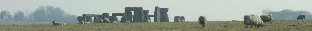
Take the footpath past the back of the Leisure Centre out to Stratford-sub-Castle. From the east side of Old Sarum, there is a straight path running north to the factory by High Post. Go down the lane to Great Durnford, turn left and then cross the river. From the village of Lake, walk out past Springbottom Farm to Stonehenge.
The Plain
From Stonehenge, north over the Cursus and then left along the road. You can get round Larkhill Camp on the west side, and pick up a track that runs past Robin Hood's Ball to the "Bustard Hotel". Then north across the ranges to the old signpost, and north again over Black Heath to the security hut at Redhorn Hill. This section is normally open on Sundays, but at other times it may be closed. There is an MOD website which covers public access to Salisbury Plain. The Live Firing Information phone number is 01980 674763.
Vale of Pewsey and Avebury
The fiddly bit - well, there had to be one. Descending from the Plain half a mile east of the Redhorn hut, you either stick to the lanes as far as Honey Street, or try to find your way through the fields. Whichever way you go, drop in at the "Barge Inn" by the canal at Honey Street. After Alton Barnes, the way is obvious again; up past Adam's Grave and Walkers Hill, and then down from the Wansdyke to East Kennett and Avebury. You can take the road along the Avenue, or follow the river past West Kennett Long Barrow and Silbury Hill.
Avebury to Oxford
A long section, but very straightforward. Follow the Ridgeway to Streatley-on-Thames, and the Thames Path from there to Oxford. Easy really. Both are well-marked trails (the official variety) with no real chance of getting lost.
Other sites
See also the Ridgeway section.
- Andy Bleach walked the Thames Path. Stages 13 to 15 cover Streatley to Oxford.
- David Cotton also describes the walk.
General information:
- Salisbury: local info including accommodation.
- Ramblers Association: Thames Path page.
- National Trails: Thames Path page.
- Walking Pages: contact details for Tourist Information Centres in the Avon valley area.
- Rural Ways: Thames Path page.