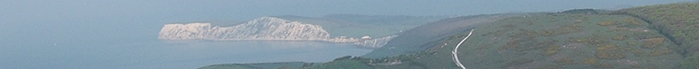
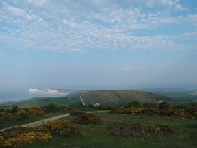
It was after seven when I emerged from Brighstone Forest and rejoined the Tennyson Trail. I was on an escarpment running from east to west. Far away to my left St. Catherine's Point rose up grey in the morning mist. Below lay the coastal plain and the muddy chines along the margin of the sea. And westward the long sweep of water ended at last in a great headland flanked by white cliffs.
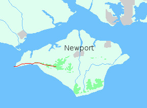
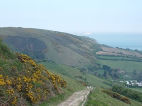
From Brighstone the trail follows the crest of the ridge. Occasionally it dips to some col, where a road crosses the chalk wall, but quickly it regains height and marches on.
Soon the forest is left behind. Now the view extends northward to Yarmouth and the mainland. For mile after mile the track rolls on, a rollercoaster over the hills.
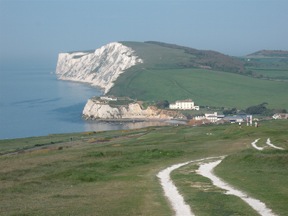
It was hot when I reached Freshwater Bay, and my feet were sore after pounding the hard chalk, but the clear water quietly lapping the shingle was very refreshing. Having cooled down, I looked around for something to eat. There are a couple of cafés near the bay, but they were closed. So I dug out some emergency rations, in the shape of a packet of biscuits, and plodded on.
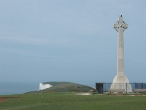
From Freshwater I began the long climb to the monument on Tennyson Down. It was placed there in memory of Alfred, Lord Tennyson, the poet laureate, who lived nearby.
The last mile over West High Down to the Needles was like walking off the edge of the world. The ridge narrowed to a green strip in an immensity of blue. At the base of the cliff the waters flowed; above lay the overarching sky; and I hardly knew where one ended and the other began.
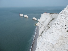
Some sense of perspective returned as I reached the Needles. From the viewpoint I could just distinguish, across Bournemouth Bay, the Purbeck Hills where the walk would resume.
From the Isle of Wight to the Purbecks it's fifteen miles as the crow flies. To get there by public transport required six separate conveyances and took nearly four hours. It must be one of the most complicated (and expensive) journeys in Britain!
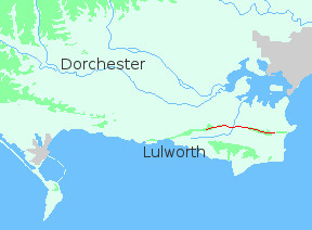
It was well after four when the bus dropped me by the side of the road, just north of Swanage. I should really have got off at Studland and backtracked to Old Harry Rocks (Purbeck's equivalent of the Needles). But having eaten little that day, I was more concerned with dinner than with covering every last mile of chalk. So I took Old Harry on trust, and set off westward over Nine Barrow Down.
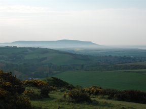
As I climbed the track to the summit I looked back. Far away, over the shoulder of Ballard Down, was a white smudge on the horizon - the Needles, where I had stood that morning.
The chalk ridge from Ballard Down to Whiteway Hill divides Purbeck roughly in two. To the north is a wide tract of heathland fringing Poole Harbour and extending inland along the valley of the Frome. South of the ridge the land drops steeply to a broad valley, before rising once more to bare uplands ending in high cliffs of Purbeck limestone.
Near Tyneham the limestone is cut by the sea. The chalk ridge too touches the coast here, before turning away towards Dorchester. Tyneham village, and the ridge and heathland beyond, are military training areas. They are generally open to the public at weekends and bank holidays (more information can be found here).
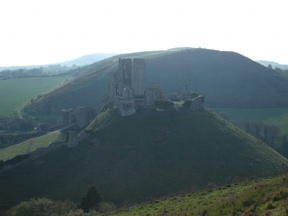
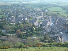
From Nine Barrow Down the main track descends gently to Corfe. Alternatively there's a permissive path leading to Corfe Gap, with fine views of the castle and the ridge beyond. The path ends in a steep flight of steps down to the village.
In the centre of Corfe, in a small square by the castle, is the Greyhound. It was Easter Saturday when I visited, and things were more than a little chaotic at the bar; but I eventually found my way out into the garden. There I ate peacefully, as the sun sank and dusk crept over ramparts and shattered walls.
After dinner there was enough light to cover a few more miles. The lowlands lay now in shadow, but the ridge was still touched with the declining day. I followed it westward, as darkness fell over the world, until I reached the woods above Creech Grange. There I camped for the night.